Site surveying and sampling
Assessing Offshore Geohazards: Site surveying and sampling of shallow, submarine landslides in coastal and deepwater environments.
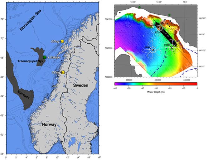
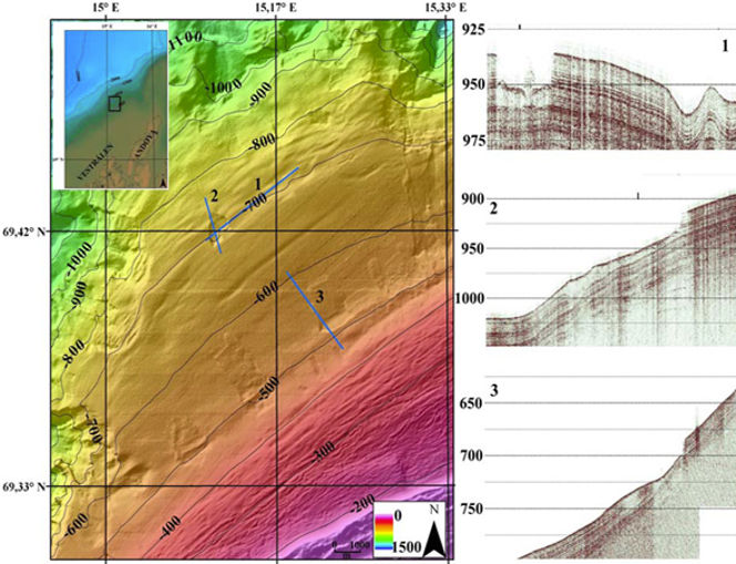
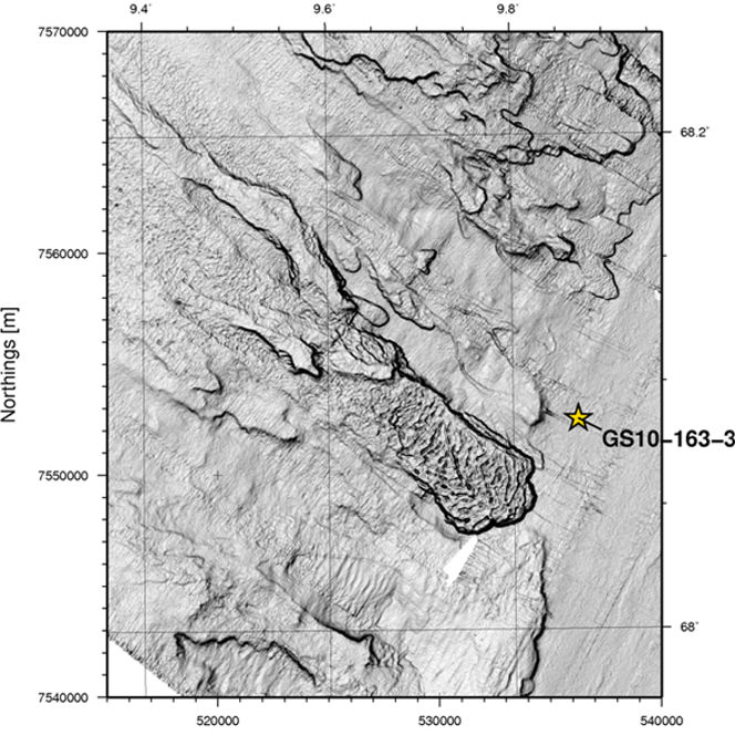
High-resolution geophysical surveying led recently to the discovery of a myriad of smaller-scale mass movements in different geological environments along the Norwegian margin, from coastal areas (Finneidfjord) to open oceans in intermediate water depths (Vesterålen) and deepwater (Lofoten) (for locations, see Figure 2). The landslides are characterized by variable geomorphological complexity, and occur in either clusters of isolated landslides (Finneidfjord, Vesterålen) or as part of a larger, multi-phase slope failure (Lofoten).
The open-water landslides lie relatively close to larger-scale mass movements or canyon systems. The slip planes often lie at shallow depths, e.g., within the top 10 m of sediment. Geophysical data indicate that the landslides are likely recent phenomena and that failure happened repeatedly and possibly frequently in different sedimentary environments. Despite the smaller dimensions, their release may affect coastal communities (tsunamis, onshore retrogression) or have dramatic consequences for seabed infrastructure.
Little is known about these landslides' sedimentary processes, pre-conditions, similarities, and differences, except that anthropogenic factors cannot be discarded for the Finneidfjord area. It is, therefore, important to further investigate these slope failures using an integrated approach. The three outstanding issues are:
- identify and parameterize the slip planes in the different settings
- understand the processes involved in failure (sedimentary processes, stratigraphy, lithology, and chronology)
- assess the present-day stability and geohazard risk
To this end, a multi-disciplinary data set was collected, consisting of high-quality Calypso cores and several gravity/piston, a wealth of geophysical data (very-high-resolution 2D topas and 3D chirp seismic, ocean-bottom seismometer data, swath bathymetry, side-scan sonar), and cone penetration test data (including dissipation tests).
Geological (non-destructive MST logging, XRF-scanning, dating, etc.) and geotechnical laboratory analyses (index tests, fall cone undisturbed and remolded shear strength, oedometer, triaxial shear strength, and direct, simple shear tests) are being conducted to shed light on these issues.
Examples of the target areas are presented in Figures 3 to 6 below.

Figure 2, left: Overview map of the Norwegian margin, with the study areas for the CDog (SEABED) and LOslope (NFR) project marked. Figure 3 (right): Survey map illustrating the data acquisition accomplished onboard R/V Seisma (NGU) and G.O. Sars (Univ. Bergen) in the Summer of 2010 for the CDog Project.

Figure 4: Example of VHR-3D chirp seismic profile (in-line) in Finneidfjord across the landslide deposit (central lobe) with unprecedented resolution. The VHR-3D system is courtesy of NOCS

Figure 5: Swath bathymetry (MAREANO) and examples of HR-2D topas seismic profiles across landslides off the Vesterålen margin (CDog project).

Figure 6: Dip magnitude extracted from part of the swath bathymetry data (R/V Jan Mayen) collected off the Lofoten margin (LOslope project) with location of the Calypso core used for geological and geotechnical analysis.
Natural laboratories
Part of these activities also further develop Finneidfjord into a natural laboratory. The underlying reasons are its accessibility and the fact that Finneidfjord hosts the three major geohazards identified by the offshore industry, being (1) (multi-phase) slope failures on a series of well-defined slip planes with block generations; (2) high sedimentation rates and thus likely excess pore pressure generation, and (3) the presence of a prominent gas front near the landslides. Part of the basin infill shows well-stratified sequences, which are ideal for testing a variety of high- to very-high-resolution geophysical mapping.
Similarly, and even more accessible, is Trondheim Bay. Also here, land sliding is a recurrent phenomenon, and it is known that part of the land reclaimed from the sea over the last decades, followed by urbanization (Trondheim harbor) subsides more than adjacent areas.
Support
- SEABED consortium* - CDog project; ICG + University of Bergen, National Oceanography Centre Southampton, MARUM University of Bremen
- Norwegian Research Council - LOslope project; ICG + University of Tromsø
- Joint ICG/NGU funding of Post-doc research position (Dr. Jean-Sebastien L'Heureux, NGU)
- NFR/NRC funding for Ph.D. fellowship (Nicole Baeten, UiT) and Senior Researcher (Dr. Jan Sverre Laberg, UiT)
* Partnership of several oil companies with licenses offshore Norway, with the aim to improve the understanding of geomorphology and geology of the region, in particular the upper 500 m of sediment.
