Themes
ICG research in the field of GIS-based physical and empirical modeling of certain slope processes is concentrated on the calculation of spatially distributed terrain attributes that are physically linked to landslide processes, and the application of these for spatial prediction of landslide hazard.
Terrain analysis and geohazard assessment
ICG research in the field of GIS-based physical and empirical modeling of certain slope processes is concentrated on the calculation of spatially distributed terrain attributes that are physically linked to landslide processes, and the application of these for spatial prediction of landslide hazard. Key tasks are the identification of source areas for landslides and delineating hazard zones given one or more source areas.
The work is based on parameterization and analysis of gridded digital elevation models (DEM), within the framework of geomorphometry. The main topics related are:
- analyses of the relationship between gravitational processes in rock/soft soil slopes and topography
- identification of relevant topographic parameters derivable from digital terrain models and quantifies their relevance to slope processes at different resolutions
Automatic landform classification based on digital elevation models
A novel approach is the segmentation of the terrain into regions of homogenous topography with uniform surface processes. For each region, new attributes then can be extracted based on its shape, internal topography, and context in the terrain.
Thus we combine the paradigm of grid-based terrain modeling, where the terrain is looked upon as a continuous surface, with an object-based paradigm where the terrain is looked upon as a mosaic of distinct units having characteristics that differ significantly from its neighbors. The main topics here are:
- methods for landscape regionalization and quantifying how they perform in identifying areas prone to slope failures using the selected terrain parameters as input
- build algorithms for the automatic classification of slopes with respect to geohazards
Multi criteria analyses in geohazard assessment
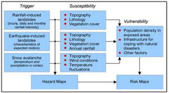
The prediction of areas affected by landslides (hazard) and the estimation of damages (risk) over large areas (regionalization) requires a combination of factors governing the hazard processes (e.g. topography, precipitation, etc.) that are not physically comparable.
This is done within the framework of cartographic modeling or multi-criteria analyses, using regional map layers representing the spatial distribution of an attribute that expresses the degree to which the attribute contributes to the overall favourability of various locations (index maps). A weighted overlay then results in a ranking on a favourability scale.

Figure 4. Principles of combination of datasets related to landslide triggers and landslide susceptibility for deriving regional hazard maps and risk maps.
Remote sensing and geohazard assessment
Process interactions and chain reactions, global-change-induced shifts of hazard zones, and the potential for the reach of many types of natural disasters make it necessary to apply modern remote sensing techniques for the assessment of geohazards.
Hazard source areas may be situated in remote regions, often difficult to access for physical and/or political reasons. In this project, air- and spaceborne remote sensing methods suitable for geohazard assessment and disaster management are developed and applied, or such is planned:
- image classification and change detection techniques
- digital terrain models (DTMs), derived from optical stereo data, synthetic aperture radar or laser-scanning
- fusion of satellite-stereo-derived DTMs with the DTM from the Shuttle Radar Topography Mission (SRTM)
- measurement of changes in terrain geometry using repeat air- and spacecraft-derived DTMs
- surface displacements on glaciers, permafrost, and landslides
- multidimensional combination of DTMs, spectral image classifications, and multitemporal data
- modelling of hazard potentials based on remotely sensed information and geographic information systems (GIS)
In addition, we work towards better dissemination of remote sensing expertise to institutions involved in geohazard assessment and management in order to exploit the large potential of remote sensing in this field.

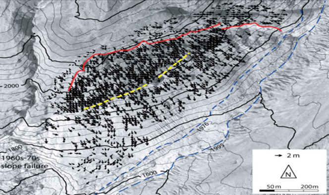
Figure 6. Displacements on a rock mass creep near the tongue of Aletsch Glacier, Swiss Alps (46.4 deg N, 8.0 deg E), derived on the basis of orthoimages from 1976 and 1995. In the lower left corner the deposits from a rock slope failure from the late 1960s to early 1970s are located. The solid red line to the north marks the upper scarp of the slide; the dashed yellow line in the centre marks the Little Ice Age (LIA) glacier moraine (about 1850). To the south-east, the glacier boundaries of 1976 and 1995 are marked by blue dashed lines. The underlying orthoimage from 1995 is based on aerial photography by the swisstopo flight service. Maximum terrain displacement amounts to 2 m. The retreat of Great Aletsch Glacier from its LIA extent and the accompanying loss of ice thickness (up to 300 m) caused a stress redistribution in the valley flank and related destabilisation.