Flatbre moraine test site
A major debris flow occurred in 2004 in Fjærland (Norway, Sogn og Fjordane) due to the breaking of the Flatbre moraine damming a glacial lake.
The questions to answer now are, for instance, whether the moraine ridge damming the glacial lake is ice-cored, partly or fully. It will help to understand if the breaking could be due to significant melting inside the moraine, thus weakening the whole structure. The moraine is about 600 m long in total, about 40 m high and its slope is about 35 degrees.
The ridge is approximately 1m wide with a path on top of it. The particles in the moraine range from the size of clay to large boulders of several m3.

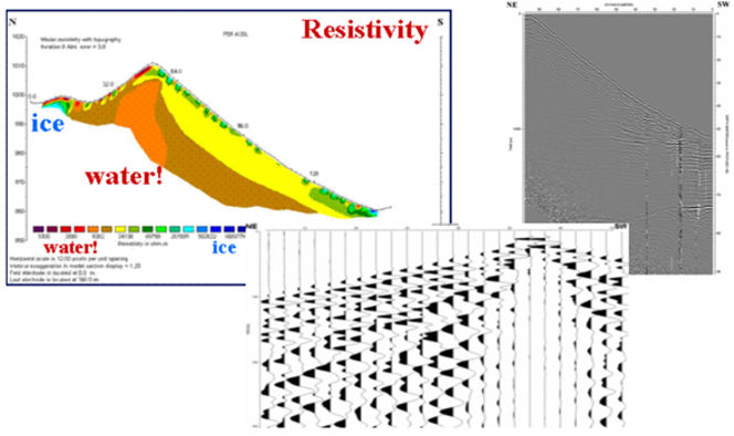
Figure 5. Flatbre moraine 2006 field work. a) Resistivity profile across both new (left) and actual moraine (right) showing the clear difference in resistivity between ice and water-saturated moraine material. b) GPR profile on the distal side of the moraine: water-table, layered sediments and bedrock are visible at the base of the moraine. c) Example of a seismic recording on 24-channels for a profile across the moraine.
At the inquiry of fellow researchers studying that case, geophysical field works were carried out in September 2006. Resistivity, GPR, and seismic measurements were gathered and are under processing and analysis (Figure 5). Preliminary results can be found in ICG report 2006-T1-1, which were presented at two EGU conferences in 2007 (Lima, March, and Vienna, April) and final results can be found in Lecomte et al. (2008).
All 3 methods worked very well, which was indeed surprising for the seismics. There is no indication of ice inside the main moraine, only in the smaller and new moraine under formation on the upstream side.
Though the whole moraine seems to be much saturated with water (percolation), which explains the good propagation of seismic waves (a sledgehammer was sufficient to acquire very good quality data), its central part seems especially wet.
Water is indeed seeping there at the base of the moraine, as seen in summertime. ICG is considering monitoring the moraine, especially to map and follow the water flow. The 2006 geophysical data may be released for research purposes.
This activity was coordinated with the ICG Slide dynamics project.