Geological model development and stability analysis
The most fundamental input for rock-slope failure assessment comes from the geological dataset. Hence, realistic models based on an in-depth understanding of structures, 3D kinematics, and stability related to friction (fractures, fault rock membranes) are crucial.
The following topics will be focused on.
Digital elevation models (DEM)
DEM will be used to characterize structural patterns of importance for instability features (e.g., sliding planes and wedges). Recent technologies such as airborne light detection and ranging (lidar) or the ground-based laser scan provide digital elevation models (DEM) with a sub-metric resolution.
A high-resolution DEM can provide a first image of the phenomena: geometry and limits of the instability, main sets of discontinuities and their orientations, kinematic tests of planar sliding or wedge failure, and a first estimation of the volumes involved.
These methods have already been tested on two Norwegian sites (Oterøya and Åknes) and new data from the Tafjord area are now available. This project will focus on two aspects: (1) the acquisition of ground-based and airborne laser scan data of rock slopes and (2) the development of methods for a preliminary assessment based on a high-resolution DEM.
3D geometry of rock-slope failures
The focus will be on detailed investigations of slope failures to identify diagnostic structures for such features. Mapping requires geophysical methods (2D resistivity, seismic) to identify deeper and sole structures. Drilling should also be performed if possible. Priority will be given to the localities Åkerneset and Oppstadhornet in Møre & Romsdal and Nordnes in Lyngen, Troms.

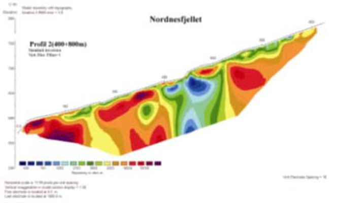
A 2D resistivity profile crossing a large rock-slope failure at Nordnes in Lyngen, Troms county. In general there are high resisitivity values, except for a nearly vertical zone showing distinct lower values (blue colours). This zone represents the major fractures in the upper part of the sliding mass, demonstrating that the slide is at least 100 m deep in the upper part.
Geo-mechanical uncertainties in rock slope stability assessment
Current consensus and numerical models for rock-slope stability, utilized in risk assessments, are based on shear-fracture characteristics. Ongoing outcrop studies on collapsing mountain sides (e.g., Blikra et al. 2004; Braathen et al. 2004; Dahle, 2004) clarify that most rock-slope failure areas contain both shear (i) shear - and (ii) tension fractures, as well as a basal shear surface commonly covered with a membrane of crushed rock (fault breccia/gouge).
The project will address uncertainties related to variables applied in numerical rock-slope stability models, including laboratory analysis (e.g., ring-shear study). Especially important is to establish the shear-strength relationships for unconsolidated, water-saturated fault rocks along sliding planes and to establish frictional relationships for large-displacement rock fractures in gneiss.

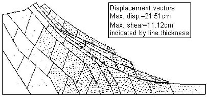
Profile illustrating a two-layer model for pre-avalanche deformation in a rock-slope failures area. Text boxes describe factors and mechanical properties that must be evaluated in stability assessments (Braathen et al., 2004).